FM Multiplex Broadcasting
FM multiplex broadcasting is transmitted simultaneously from 53 locations across Japan (and 468 relay stations) by NHK’s FM radio transmitters, providing road traffic information for large coverage areas (the prefectures where it is broadcast as well as areas near the borders of adjacent prefectures).
The reception area for each region is roughly the same as that of NHK FM radio, transmitting data volumes equivalent to 50,000 characters every two and a half minutes, twice within each five-minute interval.
* The information provided is for reference only. Due to how information is gathered and processed, the information provided may differ from actual conditions. Additionally, although the information is updated at five-minute intervals, it may take some time for the information to be displayed, so the information displayed is not always the latest information. Please obey any traffic restrictions that are actually in place.
Information provided
- Traffic Congestion Information
- Travel Time Information
- Traffic Restriction Information
- Traffic Hindrance Information
- Parking Lot Information
- Weather Warnings and Emergency Warnings
- Heavy Rain Area Information
- Emergency Information
- Event-Related Traffic Restriction Notices
-
 Go here for details
FM Simple Graphics – Display Example
Information related to traffic congestion, traffic incidents, etc. is provided in the form of simple graphics and icons.
VICS WIDE
VICS WIDE doubles the transmission capacity of FM multiplex broadcasting compared to conventional systems. It provides emergency warnings related to weather and other conditions as well as heavy rainfall area information, emergency information, and event-related traffic restriction information.
-
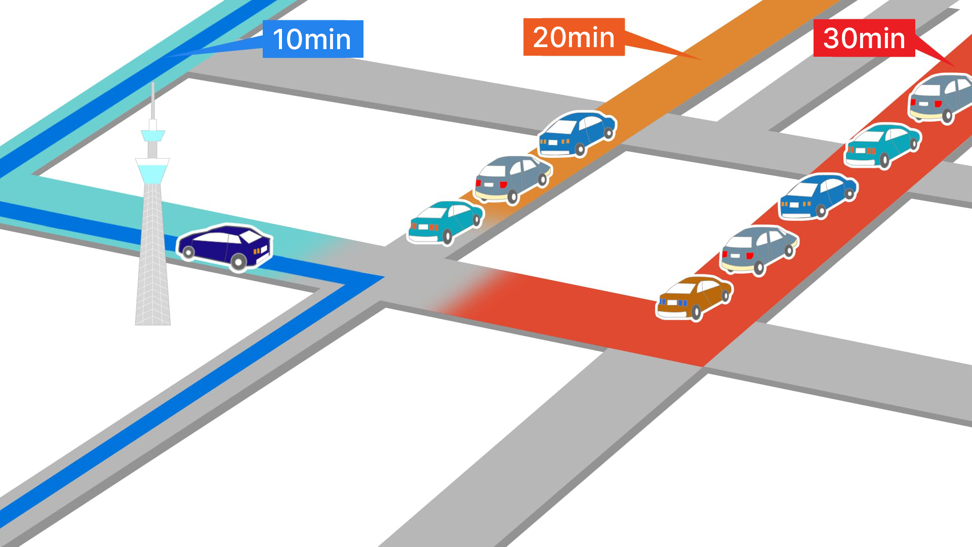
Highly accurate
congestion informationProviding link travel time* for ordinary roads makes it possible to see the travel time for multiple routes. This allows VICS to provide more accurate traffic congestion information.
* Link travel time: The time required to traverse a specific route segment, such as the distance between two road intersections
-
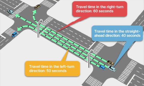
Providing detailed
traffic informationProbe information enables VICS to provide link travel times for traveling straight through an intersection, turning right, and turning left, based on vehicle travel path information. This makes it possible to select optimal routes amidst constantly changing traffic conditions.
* The way in which route selection is carried out may vary according to the car navigation system.
-
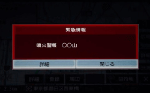
Emergency warning pop-ups
for weather and other conditionsIn addition to the weather and tsunami information previously provided by VICS, information on volcanic eruptions is now included as well. Emergency warnings*, with the exception of earthquakes, appear as pop-ups, giving the driver quick access to information in an emergency.
* Emergency warnings are provided by the Japan Meteorological Agency
-
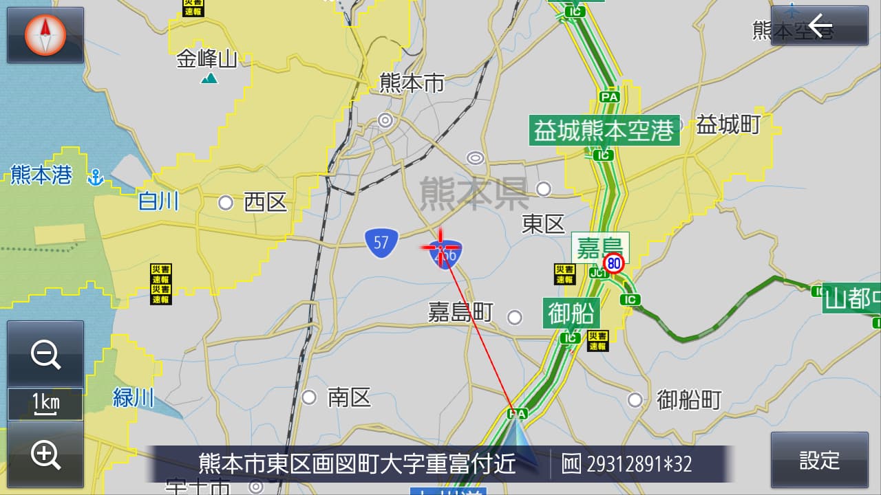
Displaying heavy
rain areasIf heavy rainfall* in excess of 50 mm/h — a level of rain intensity capable of impairing a driver’s forward visibility — occurs, the car navigation system displays the rain area on the map screen with a grid of 250-meter squares. Indicating the rain area improves safety by allowing the driver to take a detour or avoid crowded roads.
* Quantitative data is provided by the Ministry of Land, Infrastructure, Transport and Tourism.
-
Displaying planned event-related
traffic restrictionsPrior to events taking place, car navigation systems can display areas where restrictions are expected to be in effect.
This allows drivers to see restriction-related information in advance in order to alleviate congestion.
To access VICS WIDE information, you need a car navigation system that is compatible with VICS WIDE.
Additionally, the functionality for displaying VICS information may vary according to the car navigation system model.
For more information, please refer to the user’s manual for your car navigation system.